Dangerous US/NATO Expansion in Norway
Global Network Against Weapons & Nuclear Power in Space
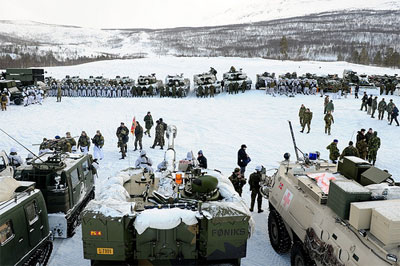
(June 1, 2021) — In recent years, the US and NATO have been militarizing the Arctic through Norway as a means to confront Russia. This militarization is increasing tensions between nuclear-powered nations. As the Arctic melts away, these powerful nations are competing for dominance in the region as new routes are established, building new military bases and constructing new radars. Meanwhile, less efforts are placed in diplomacy.
“The Satellite War” by Bård Wormdal
A review by Dave Webb
“The Satellite War”, written and published privately by Norwegian journalist Bård Wormdal, deals with, among other things, Norwegian double standards on security policy in the Arctic. . . . [I]t provides some new and important information on how the increasing militarisation of space is presenting challenges to existing treaties and agreements and how we need always to be vigilant to ensure that their principles are not eroded.
The book begins [with a] foreword explaining the author’s entry into the subject through the Vardø radar controversy. In 1998, a Raytheon Have Stare “high-resolution X-band tracking and imaging radar with a 27-meter mechanical dish antenna” which had been operational at Vandenberg Air Force Base in California since 1995, was quietly dismantled and moved to northern Norway.
In California, it was used in early development tests of the US National Missile Defense (NMD) program and in Norway it was reassembled by the US and Norway under the project name “Globus II” at Vardø just 40 miles from Russian border. The US and Norway claimed that the radar would be used to monitor space debris but Russian and US experts demonstrated how its principal use would be to collect detailed intelligence data on Russia’s long-range ballistic missiles.
In June, 2000, 2 years before George W Bush withdrew from the 1972 ABM Treaty, the Norwegian intelligence agency actually admitted, that the US did intend to use it as a basis for missile defense purposes. The US was therefore violating the ABM Treaty, which did not allow the deployment of such a radar outside US territory and, in 2005, Bård made a documentary program with Pål Sommer-Erichson for Norwegian television on Vardø which uncovered its true role.
From the lessons learned from this exercise and with encouragement from a Norwegian military journalist, Bård then becomes familiar with, and takes on, the issue of Svalbard.
Svalbard is a remote archipelago in the far north that belongs to Norway under the 1920 Treaty of Svalbard made between Norway and Russia. However, this treaty strictly forbids military operations of any kind from being carried out there but there was some concern that the activities of a satellite station were violating this agreement.

Kongsberg Satellite Services (KSAT, a commercial Norwegian company, 50% owned by the state) runs a satellite receiving station known as SvalSat in Svalbard. KSAT has other uniquely positioned ground stations at Tromsø and in the Antarctic (TrollSat). Together, these stations can download information for all 14 daily transits of polar orbiting satellites.
Bård shows how SvalSat downloads images of the earth that are used for intelligence and military activities. For example, during the Libyan war Landsat images were sold by the Italian company e-GEOS to the Italian Armed Forces; satellite images were sold to the US Armed Forces during the War in Afghanistan and images of North Korean installations have been sold to the US. These were downloaded from different satellites, all using SvalSat as a ground station.
Bård also reveals how the Pentagon has paid for fiber optic cables to be laid from the station to the mainland to enable the transfer of the huge amounts of data that satellite images generate. Bård’s book provides conclusive evidence of treaty violations and shows how this evidence is usually either denied, evaded or ignored by the Norwegian government.
Bård goes on to describe how one of the other KSAT stations — TrollSat, established at the other end of the world in Antarctica — can serve low Earth orbit satellites. Operations control is carried out from Tromsø and satellites using TrollSat include Radarsat, GeoEye and WorldView which serve commercial and military customers and the station is also used by Galileo, the European satellite global navigational positioning system.
As Bård points out, the 1961 Antarctic Treaty states that “Antarctica shall continue forever to be used exclusively for peaceful purposes and shall not become the scene or object of international discord” and it also forbids “any measures of a military nature” but the Norwegian government and NATO allies, deny or ignore all the evidence laid out in Bård’s book.
The Norwegian Labour government Minister Jonas Gahr Støre has assured the Norwegian parliament that Norway follows the Svalbard Treaty in a strict manner. The problem is that it is not always easy to find out what kind of data is being transmitted through satellite receiving stations. However a major clue must be who the final end user is — it should not be too difficult to ensure that these details are made available to the relevant authorities for monitoring? However, as usual governments tend to turn a blind eye to situations that may conflict with the interests of their military or military alliances (Norway is a member of NATO) or of large corporations.
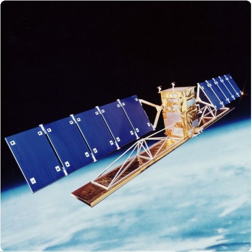
Radarsat
This is a useful book perhaps not as polished as it might have been if a publisher had been involved. However, as a seasoned journalist, Bård describes well some of the quite complex technological aspects of the use of space by the military. He obviously recognises the importance of what is happening here — that satellite information of use to the military is handled by a number of different companies/organisations performing a range of functions — from satellite data collection and transmission, to data collection via ground based receiving stations, to eventual dissemination and delivery to a final destination (customer).
At each stage the exact nature of the data may or may not be known by those handling. The data has become a commodity bought and sold at the various stages of its collection and transmission. It is the final customer who transforms it into information and very often that customer may be the military. This story is an excellent illustration of the major problem of the ‘dual use’ of satellite related technology.
It is not surprising that, as well as offering cost savings, dual use systems are becoming quite common, enabling the military to act as a consumer, leaving many of the technical concerns to commercial companies who can charge for their facilities.
The fact that it has been published and printed by the author and that it is so inexpensive (practically free) points to his desire to distribute this information as widely and as quickly as possible. Bård spoke at a recent meeting of the Global Network Against Weapons and Nuclear power in Space, in Kiruna, Sweden.
The audience consisted of a number of international activists concerned about the increasing militarisation of space and included a large number from Scandinavian countries. Very few of those assembled knew much about this Norwegian government’s contribution to the use of space and ground based components to plan for and execute wars.
It seems that it is up to concerned citizens of Norway, and of the world, to demand that the responsibilities laid out in treaties and agreements are taken seriously and that any existing violations be immediately stopped.
The Satellite War is available through Amazon via this link.
Posted in accordance with Title 17, Section 107, US Code, for noncommercial, educational purposes.