Downstream Impact:
Analyzing the Environmental Consequences
of the Kakhovka Dam Collapse
Following the destruction of the Nova Kakhovka dam, CEOBS was asked by UNEP to provide an initial assessment of the potential risks to the environment. Our analysis focused on identifying industrial or infrastructural facilities with a high pollution risk, and an early assessment of the impact on ecologically important areas. Leon Moreland introduces the findings of our rapid analysis and situates them in the wider environmental context of the disaster.
The Dam and Its Destruction
Leon Moreland / Conflict and Environment Observatory
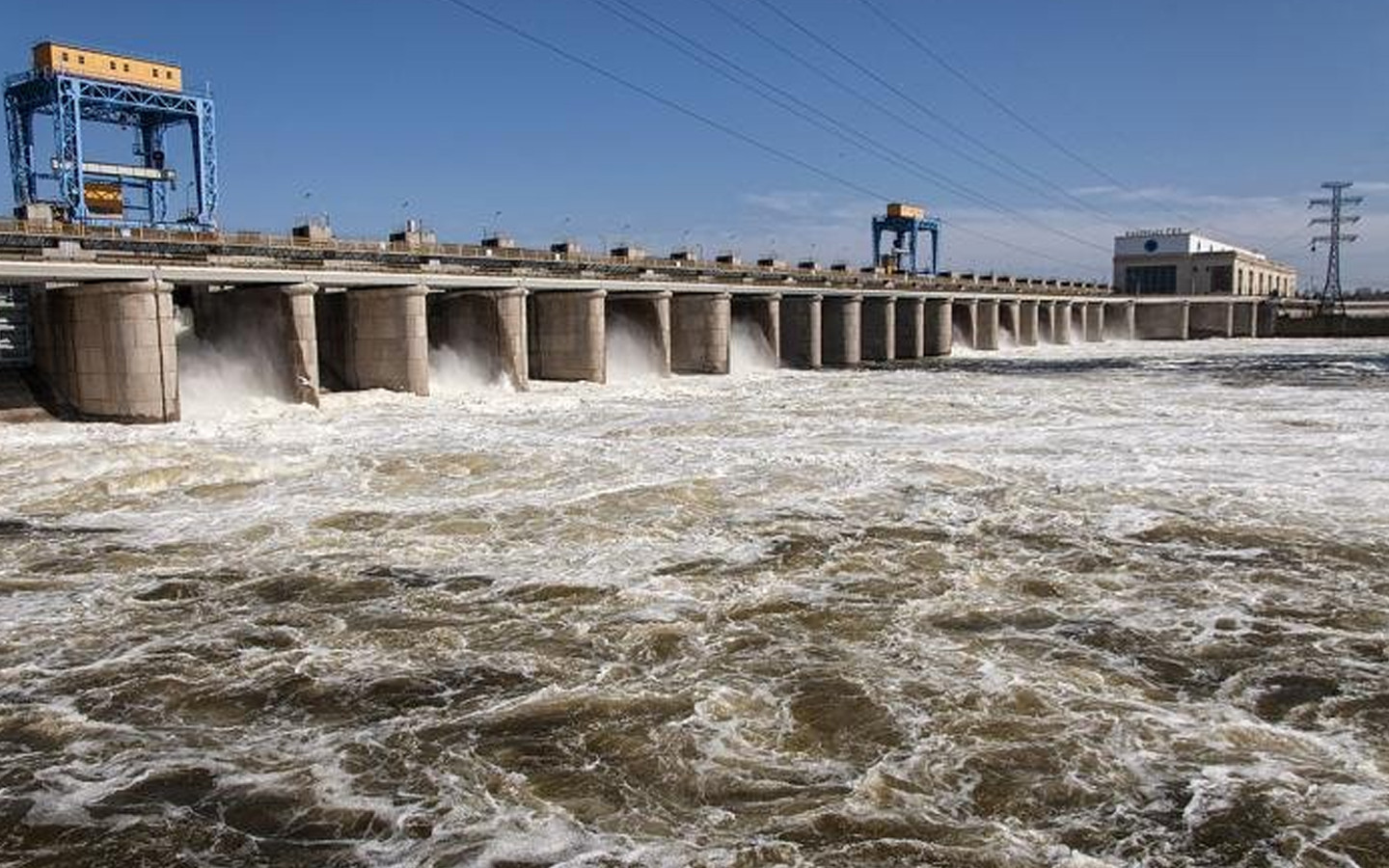
(July 2023) — The Kakhovka hydroelectric plant near the town of Nova Kakhovka in southern Ukraine was completed in 1956. At 18 km3 the dam’s upstream reservoir was the greatest by volume in Europe, and at 2,092 km2, its second largest by surface area.1
The facility provided three key services: generation of hydroelectric power, irrigation of cropland in southern Ukraine and northern Crimea, and safety at the Zaporizhzhia nuclear plant by supplying its cooling ponds.
The dam’s installed hydroelectric capacity at the time of its destruction was 357 MW, approximately 5% of Ukraine’s total hydropower, and it was the sixth and final dam in the Dnipro cascade — a series of dams and reservoirs along the highly engineered River Dnipro. The dam itself was massive, 37 m tall and around 3.2 km in length; drone footage suggested that the section initially breached in the incident was around 85 m long.
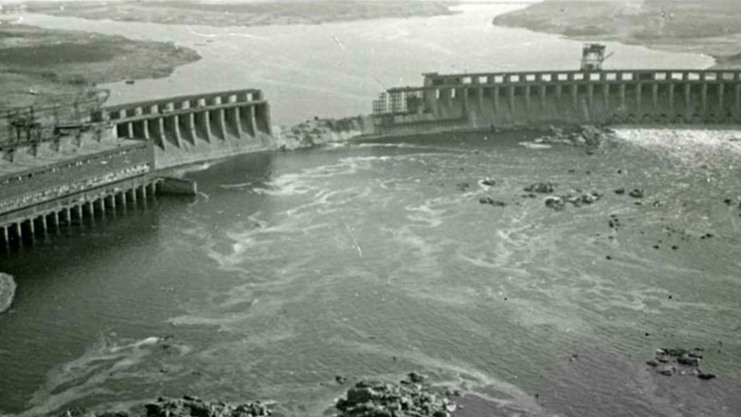
In the early hours of June 6th, seismic monitoring identified two large explosions in the vicinity of the dam, which corresponded with social media reports of its collapse. Technical assessments suggest that explosives would have had to have been set deep within the dam’s structure to cause sufficient damage.
However, it should be noted that the dam had sustained significant damage throughout the conflict, and that water levels in the reservoir had dramatically fluctuated from historic lows in February, to historic highs in May. These may have been contributing factors in the dam collapse, or the scale of collapse. Russia had occupied the facility since February 2022 and, as an occupying power, was obliged to ensure its safety.
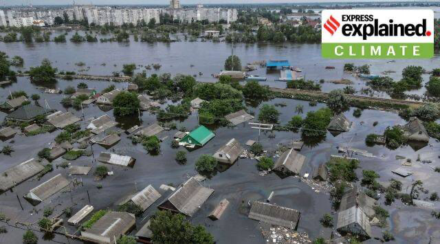
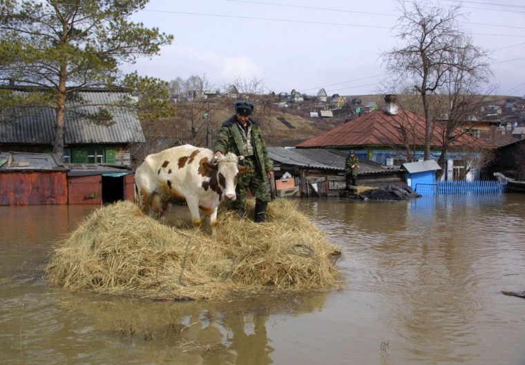
Estimates from UNOSAT suggest that approximately 620 km2 of land were flooded between the 6th and 9th June, affecting or in potential proximity to, a hundred thousand people. The dam’s destruction was branded “an environmental bomb of mass destruction” by the Ukrainian government, and the ensuing flood event a “brutal ecocide”.
The flood affected agricultural, residential and industrial areas, as well as ecologically important habitats and military fortifications in front line areas. The flooding affected both the Russian-occupied left-bank, and the Ukrainian-held right bank of the Dnipro. In total 31 people were killed as a result of the flooding. By 13th June the flooded area had decreased to 180 km2, and between July 5th and 20th the floodwaters receded by a further 100 km2.
Flooding and Pollution
Our analysis revealed a total of 88 hazardous sites visibly impacted by floodwater.2 The flooding of these industrial facilities likely caused the release of significant volumes of fuels and other pollutants, posing a threat to aquatic organisms. In addition to pollution from larger industrial facilities, floodwaters also affected sewage pits, agricultural facilities, petrol stations and landfills in settlements on both banks.
Of the 88 facilities we identified, 49 were situated in areas of Ukrainian control, while 38 were on the Russian-occupied left bank. Significant asymmetries were reported in the emergency humanitarian response between Ukrainian-held areas and Russian-occupied areas, and these disparities may also have been reflected in any subsequent environmental monitoring and assessment.
Downstream flooding affected more than 86.54 km2 of urban areas, on both banks of the river. Topographic differences resulted in a larger flooded area on the Russian-occupied left bank. Households can be a significant source of pollution, releasing oils, household chemicals, and solid waste. There is also concern over the dispersal of asbestos fibres from damaged properties; asbestos is reported to be present in at least 60% of all roofing materials in Ukraine.
As ours was a rapid remote analysis it inevitably faced a number of limitations. In the case of pollutant releases this included the need to generalise about potential pollutants and constraints on our ability to identify particular pathways and receptors. The purpose of the analysis was to help inform subsequent more detailed assessment and monitoring activity.
The Russian-held left bank of the Dnipro features kilometres of trenches and fortified positions. These defensive sites were likely protected with landmines, used to store military materiel and will contain military wastes. It is expected that solid waste, mines and unexploded ordnance were mobilised by the flood.
A total of 117 military objects, including trenches, had been recorded along the left bank of the Dnipro. Of these, we identified 47 that were flooded. It is important to acknowledge that 38 of these military objects were built in areas of ecological significance.
The HALO Trust, which had been conducting demining operations along the right bank, was forced to re-survey previously cleared areas following the flooding. Mines can float, and The HALO Trust reported that the torrent of water was powerful enough to dislodge them, and in some cases cause 10kg anti-vehicle mines to detonate. The status of hazardous areas under Russian control on the left bank is unclear.
Ecological Impacts
We identified six areas of ecological importance that were impacted by floodwater.3 Four are adopted Emerald Network sites, and one a nominated site, which still has no name. Most heavily affected was the Lower Dnipro Delta, which is designated as a wetland of international importance under the RAMSAR Convention and is also an important part of Ukraine’s Emerald Network; we found that more than 90% of its area was inundated. While it is a wetland area, the flood intensity was greater than that of seasonal flood events, and carried a higher sediment and pollutant load.
The influence of the floodwaters extended far beyond these areas in the lower Dnipro, discharging sediments and debris into the Black Sea and along its northern coastline. Seafloor habitats may also have been affected, including the important and vulnerable Zernov’s Phyllophora Fields, situated in the northwestern Black Sea.
The sudden input of freshwater reduced the salinity of the northern Black Sea. On the 10th June it was reported that samples near Odesa were three times less saline than during normal conditions. The phenomenon was temporary but as its volume was far greater than normal summer freshwater flows into the basin may have impacted currents, water mixing and productivity in the northern Black Sea.
The influx of freshwater and its huge load of nutrients increased the likelihood of plankton blooms. Although such blooms are common due to nutrient loading from agriculture, there were reports that blooms grew 150-300 times larger than during normal conditions. Specialists from the Odesa-based Ukrainian Scientific Centre for Marine Ecology suggested that 40-50% of these blooms were potentially dangerous due to the production of toxins.
Impact on Ecosystem Services
The flooding and deposition of contaminants has and will have a significant impact on the provision of ecosystem services. This includes drinking water, groundwater supply and quality, wastewater treatment, recreation, renewable energy provision and aquaculture.
In particular, the agricultural sector will be affected. Although NASA Harvest estimated that flooding affected around 3.5-5 km2of cropland, which was significantly lower than initial estimates, upstream there has been the loss or disruption of 31 irrigation systems in Dnipropetrovsk, Kherson, and Zaporizhzhia oblasts. In 2021, these were responsible for irrigating 584,000 hectares of land in Ukraine’s naturally arid south.
The loss of irrigation will increase dependencies on groundwater abstraction, which carries the risk of falling aquifers and the salinisation of soils. Where agriculture becomes unviable, land may be abandoned and begin to revert back to steppe. Ukraine’s Ministry of Agrarian Policy and Food warned that this process could begin to happen within the next year.
![]()
Reflections
The scale and scope of the environmental impacts from the collapse of the Nova Kakhovka dam are enormous. While this post and the initial assessment focused on the flooded areas downstream, the environmental consequences for areas upstream of the dam are perhaps more profound, and likely to play out over a longer time period.
It is already clear that these impacts encompass water provision, pollution, loss of ecosystems and agriculture, but over time it is likely that other environmental dimensions will become apparent, for instance climate resilience.
Our work, which we have summarised here, was shared with the Ukrainian authorities and UNEP; UNEP’s initial assessment report is expected soon. It is expected that this will help signpost appropriate next steps, both in terms of short-term remediation, and longer-term strategies to limit the environmental and humanitarian consequences.
As noted above, care is needed in drawing too many conclusions from near-real time analyses because of their inherent and necessary limitations. For example, the UNOSAT flood level mask that we and many others used does not include all flooded areas, particularly those further north on the River Inhulets.
It is likely that the Nova Kakhovka dam collapse will go down as one of the most significant events in the environmental dimensions of the war. Our work played a modest role in a wider rapid response that was novel in the diversity and number of agencies and organisations involved.4
Such attention to a serious wartime environmental incident is welcome, and lessons from the response should inform future models for rapid environmental humanitarian responses.
Finally, it is important that such large-scale events do not detract from the smaller but more numerous incidents that are causing environmental harm on a daily basis in Ukraine, be that through redirection of financial, political or staffing resources. We continue to compile our analytical database of such incidents to ensure that environmental harm is tracked, and that remediation, recovery and advocacy activities are supported.
Leon Moreland is a Junior Researcher with CEOBS, Senior Researcher Eoghan Darbyshire also contributed to this post.
Footnotes
- Not including Russia or Turkey. Based on the Global Reservoir and Dam Database (GRanD) v1.3
- Facilities were identified using a variety of remote open source methods; risk assessment for facilities identified in the flooded area was based on: Facility type X Proximity to population X Flood Extent X Hazardous facility
- To identify the impact of the floodwaters on important habitats, we combined data from the WDPA, with a dataset developed by Ukrainian conservationists to help define sites that are or should be part of the Emerald Network. The Emerald Network is an ecological network consisting of areas of special conservation interest. Its primary objective is to ensure the enduring conservation of species and habitats that hold European importance and are protected under the Bern Convention.
- For example, situational reports and briefings have been provided by OCHA, UNOSAT, UNCT, ACAPS, PAX, and the REACH Initiative, amongst others. https://ceobs.org/analysing-the-environmental-consequences-of-the-kakhovka-dam-collapse/ – easy-footnote-4-8768
Posted in accordance with Title 17, Section 107, US Code, for noncommercial, educational purposes.